For this week’s blog post I will
be looking to compare two incredible examples of colonial architecture, and
evaluate them on their use of space and place, as well as the cultural and
social impacts of the architecture on the area. The two places I will be
looking at are the Roman colonial center of Timgad and the Wari military center
of Pikillacta. As each of these centers were built on the frontiers of their
respective empires, a strong analysis should be able to tell us how they are
similar, and in what ways they differ.
To begin, the Roman colonial
center if Timgad is located on the Northern Slopes of the Aures Mountains, in
modern day Algeria. Timgad was known for being a military settlement at the
time of its founding by Trajan. Timgad is now important today because it is
mostly recognized for the grid pattern planning characterized by large square
blocks with 90 degree intersections. This is significant because when I was
looking at the area on Google Maps, it appears extremely planned which is
extremely different from how Rome was organized, which was mostly organic.
Timgad itself consists of 144 blocks, evenly divided into four main areas, but
the Forum and the theatre take up 11 and 6 blocks respectively. This area looks
fascinating as when developed it looks like it was created to manipulate the
landscape. I believe they did this for a few reasons. One, with greater
organization it would control the flow of people and be more mathematically precise
in organization. Also, the grid pattern is important because the emperor would
live in the middle which shows how this space represents a hierarchal
structure. As you move out from the middle, the class of people declines. By
seeing how much room these places occupied, it shows the importance that size
and space played in this area. In addition, with precise grid like divisions,
it shows me the importance that organization and structure played into the
social and political values of the area. This is vital socially, because as a
person in a town you want to maintain the appearance of who you are and keep
the cultural dynamics of the area constant. Finally, another observation I made
when looking at Google Maps is that the walls in Timgad seemed smaller than the
ones in Pikillacta. This suggests to me that the area had walls as a mechanism
for defense, but due to the smaller walls, it was not the only purpose. Also
the smaller walls allow for a more open concept which is a different use of
space.


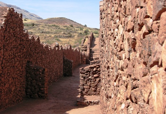
After viewing the important
features that Timgad had to offer, I looked at the Wari military center of
Pikillacta. Pikillacta is located in the Lucre Basin of Peru at the east end of
the valley of Cuzco. When Pikillacta was developed it was designed to appear
different from above as it was seen from the ground. From an aerial view
Pikillacta looks as if it is built on a flat landscape, but in reality from a
ground view is built on a slope with nearly a 100 meter elevation difference in
certain parts. When looking at the form of the structures, Pikillacta places a
large emphasis on the grid pattern as well, and uses rectangles and squares to
determine how they allocate space. Pikillacta is often described as bellicose
and regimented. From the very large walls dividing the area into a grid
pattern, it is easy to see that this area was a military outpost. Based on my
observations again, it looks as if it was built on a hierarchy of space, having
only specific ways to get to the middle where the elite lived. I am starting to
see a need in military structure to build the mass tight and in control grids,
for organization but also strategic defense. The terrain is also very uneven
which would make for better defense. I believe that this use of space and
architectural design is used for intimidation, defense, power, and attractive
organization. Finally, due to its transparent structure, you are forced to walk
through it in certain ways which could lead to one thinking that is was also
designed for administrative purposes.
 As you can see from the
comparison of the two places, they are similar in the respect that they are
both military centers, they both have a grid pattern that shows a hierarchal
use of space, they both have walls for defense, and they both manipulate the
land in which they are upon to create a symmetric land use that is appealing
yet strategic socially, politically, and from a military aspect. The
differences between the two are that in Pikillacta the walls are very large
suggesting that this was a major military base and that the use of space is
more condense and tight in formation, while in Timgad the walls are smaller
which allows for the space to seem more open in concept. Therefore, I have
found after another exploration on Google Maps the similarities and differences
that exist between Timgad and Pikillacta.
As you can see from the
comparison of the two places, they are similar in the respect that they are
both military centers, they both have a grid pattern that shows a hierarchal
use of space, they both have walls for defense, and they both manipulate the
land in which they are upon to create a symmetric land use that is appealing
yet strategic socially, politically, and from a military aspect. The
differences between the two are that in Pikillacta the walls are very large
suggesting that this was a major military base and that the use of space is
more condense and tight in formation, while in Timgad the walls are smaller
which allows for the space to seem more open in concept. Therefore, I have
found after another exploration on Google Maps the similarities and differences
that exist between Timgad and Pikillacta.
No comments:
Post a Comment